بلد - مسیریاب، نقشه - Balad
- 4.2
- Rating
- 10.00M
- Installs
- Free
- Price

 Analysis by App-foxy
When I try a navigation app, I am not only asking whether it can draw a route. I want to know if I can understand the screen quickly, follow guidance without staring at my phone, and recover calmly when a journey changes. بلد, also known as Balad, is a free Maps & Navigation app from Balad maps that puts Persian-speaking drivers and travelers at the center of the experience. Its Persian voice assistant and city-guide approach make it feel more locally focused than a general-purpose map.
That local focus matters most when I am moving through a busy city, looking for a nearby service, or trying to follow directions in Persian rather than translating every instruction in my head. The app has reached more than ten million installs and holds an average rating of 4.3 from roughly fifty-three thousand ratings, so it is clearly not a niche experiment. I found it most interesting as an everyday companion: useful for routine trips, but also worth examining through the less obvious question of who can use it comfortably and in which situations.
How clearly the map supports different ways of navigating
I find it helpful to judge Balad not just by whether it gives directions, but by how easily I can switch between listening, checking the map, and understanding the destination area. In this section, I’ll focus on when each approach is most useful and how a little preparation can make the journey less distracting.
You May Also Like

 AccuWeather: Weather Radar
AccuWeather Review: A Quick, Clear Forecast for Everyday Decisions
For everyday plans, the best forecast is the one you can understand quickly. AccuWeather makes rain timing, radar, and local conditions easy to act on, with a few trade-offs.

 Hill Climb Racing
Why Hill Climb Racing Still Turns Crashes Into One More Run
A tiny car, a bumpy hill and one more upgrade: Hill Climb Racing keeps resurfacing because its simple chaos makes every near-miss feel personal.

 AliExpress - Shopping App
AliExpress Makes Global Shopping Feel Personal, but Shoppers Bear the Risk
AliExpress turns a global marketplace into a pocket-sized discovery engine. Its reach is useful, its shopping loop compelling, and its trade-offs easy to miss.

 Lords Mobile: Kingdom Wars
Lords Mobile Is a Kingdom-Building Routine, Not a Quick Match
A case-by-case verdict on the building, battles, device demands, and social commitments that make Lords Mobile rewarding for some players and exhausting for others.

 PDF Scanner app - TapScanner
TapScanner Makes Paperwork Easier to Capture, Check, and Share
TapScanner makes scanning with a phone feel less like a rescue operation and more like a dependable step in getting work done. Its capture tools are useful, though not flawless.

 Block Blast!
 Shows How Much a Puzzle Game Can Leave Out
A quiet grid game shows why puzzle players increasingly value instant clarity, repeatable skill and low-pressure play—and where the genre still needs to catch up.
More From Our News Desk
View All News


Readable guidance for ordinary trips
The first strength I noticed is the relationship between the visual map and spoken guidance. A map can contain plenty of information and still be tiring if I need to decode every turn while driving. Balad’s Persian voice assistant reduces that pressure by making the route understandable through listening. For a Persian-speaking user, that is more natural than relying on instructions in another language or switching between map labels and translated directions.
I would still prepare the route before moving. Looking at the map while stopped makes it easier to understand the general shape of the journey: where the route begins, which major roads it uses, and whether the destination sits inside a dense street network. Once I start driving, I prefer to treat the voice guidance as the primary channel and the screen as confirmation. This is a safer and more accessible habit for anyone who finds sustained visual attention difficult.
For people with limited reading comfort, the Persian spoken guidance can be especially valuable. It does not require the same effort as reading small labels, and it can help users who are more confident listening than interpreting a busy map. The benefit is not limited to disability. A driver carrying passengers, a courier checking an unfamiliar address, or someone traveling in poor visibility can all gain from instructions that do not demand constant screen reading.
City information beyond a simple route
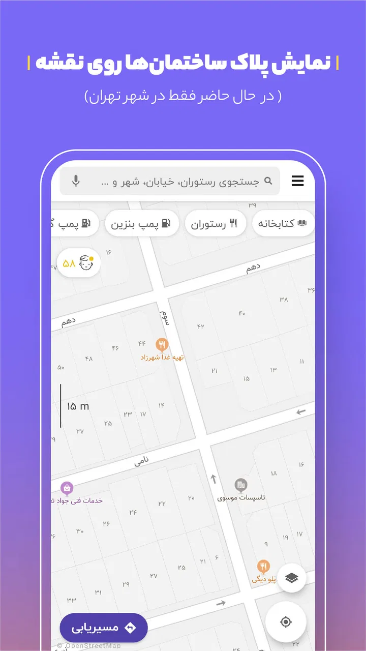
Balad is more useful when I treat it as a city guide rather than only a line between two points. That broader role changes how I plan an outing. Instead of opening a separate map for the route and another service to understand what is nearby, I can begin with the destination and think about the surrounding area. This is helpful when the real question is not simply “How do I get there?” but “What will I find once I arrive?”
That workflow can support people who need more preparation before leaving home. Someone with limited stamina may want to identify the destination area in advance and avoid unnecessary detours. A person who becomes anxious in unfamiliar places may feel more comfortable reviewing the route and nearby city information before starting. I would not assume that every listed place is equally suitable for every need, but having the area represented in one navigation environment makes planning less fragmented.
One practical tip is to use the city-guide side of the app before the trip, not while already under pressure. I find that route decisions are easier when I separate planning from movement. First I check the destination and the surrounding streets; then I begin navigation. This simple order reduces the amount of visual and mental switching required during the journey.
Useful comparison with familiar alternatives
Compared with a broad international mapping service, Balad’s clearest advantage is its Persian-first identity. A large global alternative may be familiar to more travelers across countries, and it may suit someone who regularly changes languages or moves between regions. Balad makes more sense when Persian instructions, local context, and city-focused use are central to the trip.
Compared with a dedicated navigation tool that concentrates only on turn-by-turn driving, Balad offers a wider starting point. I can approach a journey as part of a city visit rather than as a purely mechanical route. The trade-off is that a broader app can feel less focused if I only want the quickest possible driving instruction. My choice would depend on the task: Balad for Persian-centered city travel and everyday local discovery, and a more globally oriented service when international consistency is the priority.
What the version and device requirements mean
The current version is 4.74.1, and the app supports devices running Android 4.4 or later. That relatively broad operating-system support is useful for people who keep an older phone, including users who cannot easily replace a device because of cost, setup difficulty, or personal preference. It also means Balad can be considered by households where not everyone has a recent handset.
At the same time, support for an older operating system does not guarantee that every phone will feel equally comfortable. Screen size, speaker quality, battery condition, and general performance can all affect a navigation experience. On an older device, I would test the app at home, check that the voice is easy to hear, and make sure the phone can remain visible without blocking the driver’s view. The software requirement is only one part of practical access.
Motor and sensory considerations in real use
Navigation is often used in conditions that make ordinary phone interaction harder. I may be wearing gloves, carrying bags, walking with a cane, traveling with children, or trying to keep one hand available for another task. In those moments, the best interface is the one that minimizes repeated tapping. Balad’s voice-centered guidance helps after a route has started because I can listen instead of constantly touching the display.
For users with hearing loss, spoken guidance alone may not be enough. I would keep the visual route available and make sure the phone is positioned where it can be checked safely. For users with low vision, the map may still require too much detail even when the voice assistant is helpful. Increasing the phone’s system text size or using a larger display may improve general readability, but I would not confuse those device adjustments with a guarantee that every map element will scale perfectly.
Users with motor difficulties may also face a different challenge: beginning or changing a route can require precise interaction at exactly the wrong time. My advice is to complete searches and route selection while stationary. If another person is available, having them handle the initial setup can make the trip easier without taking away the user’s control over the journey itself.
A less obvious trade-off concerns audio. Voice navigation is convenient, but it can compete with music, conversation, traffic noise, or hearing devices. I would test the balance before relying on it. In a quiet room, the instructions may seem perfectly clear; beside a busy road or inside a crowded vehicle, they may be harder to follow. A phone speaker, headset, or vehicle audio connection may change the result, so the right setup depends on the user’s hearing and surroundings.
A realistic everyday scenario
Imagine I am taking a relative to an unfamiliar clinic in a crowded part of the city. My relative has difficulty reading small labels and does not want to ask for directions at every turn. Before leaving, I search for the destination, inspect the surrounding streets, and make sure I understand where the final approach will be. During the drive, I listen to the Persian instructions and use the screen only when stopped or when I need to confirm the next major turn.
That approach has two advantages. It reduces the amount of reading required, and it gives me a chance to notice problems before the journey begins. If the destination is on a narrow street or surrounded by several similar roads, I can mentally prepare instead of discovering the confusion at the last moment. The app does not remove every barrier, but it can move some of the difficult thinking from the most stressful part of the trip to the planning stage.
Situational access for drivers, walkers, and passengers
Balad’s usefulness changes depending on whether I am driving, walking, or simply helping someone else navigate. A driver benefits most from spoken guidance and a preplanned route. A passenger can take a more active role by checking the map, reading nearby information, and helping with route changes. For someone traveling independently, the ability to prepare the journey in advance may be more important than any individual map detail.
I also see value for family members supporting older adults. A relative can help set up the destination before the trip, then leave the traveler with a simpler listening-based experience. This can preserve independence better than giving a long series of verbal directions that are easy to forget. The helper should still avoid assuming that the user can hear every instruction or interact quickly; a short practice route is a sensible way to discover what works.
For pedestrians, situational awareness becomes the priority. I would not keep my attention fixed on the screen while crossing streets or moving through crowded areas. The city-guide angle can help with planning, but the app should support observation rather than replace it. A user with balance, vision, or attention difficulties may benefit from stopping at safe points to check the route instead of trying to navigate continuously while walking.
People who are sensitive to sensory overload may appreciate reducing the number of separate apps involved in a trip. One place for mapping and city information can mean fewer screens and fewer changes of context. However, a dense map can still feel overwhelming. I would zoom in only when needed, plan the route in quiet surroundings, and avoid making last-minute searches in a noisy or crowded location whenever possible.
Where the experience still has barriers
My main reservation is that local language support does not automatically equal complete accessibility. Persian voice guidance is a meaningful advantage, but users may still encounter small map text, visually busy screens, difficult touch targets, or instructions that arrive when attention is already divided. The app is easier to use when the trip is prepared calmly than when I am trying to solve several problems at once.
Another barrier is dependence on the phone itself. A weak speaker, a damaged screen, low battery, or an inconvenient mounting position can undermine the experience. This is particularly important for older adults and users with sensory or motor limitations, because a minor hardware problem can turn a manageable interaction into a frustrating one. I would consider a car mount, a charging plan, and a backup way to identify the destination before starting a demanding trip.
I also would not choose Balad automatically for every traveler. Someone who moves between countries, needs a consistently international interface, or prefers a navigation ecosystem already shared with friends and family may find a larger global alternative more practical. Likewise, a user who wants only highly focused route guidance may prefer a simpler tool. Balad’s strengths are most apparent when Persian communication and local city use matter more than universal familiarity.
There is also a human barrier that no map can solve: destination ambiguity. Similar names, entrances on different streets, and complicated final approaches can still cause confusion. I recommend checking the destination context before departure and confirming the final location with the person or organization you are visiting when the trip is important. That is not a criticism unique to Balad; it is a realistic part of using any navigation app.
Who should try it, and who should think twice
I would recommend Balad to Persian-speaking Android users who want navigation that feels native to their language and who appreciate having city information alongside route planning. It is particularly suitable for routine urban travel, family-assisted journeys, and drivers who prefer listening to instructions rather than reading every turn. The free price also removes the most obvious financial barrier to trying it.
I think it is a good candidate for older phones as well, since the minimum operating-system requirement reaches back to Android 4.4. Still, I would judge the actual experience on the individual device. If the screen is hard to read, the speaker is weak, or the phone slows down under normal use, the user may need practical adjustments before relying on it for unfamiliar travel.
I would think twice if I needed a tool designed primarily for international travel, if I could not comfortably hear spoken directions, or if I required a navigation interface whose accessibility behavior had been formally documented for a particular disability. In those cases, I would compare Balad with an alternative that better matches the specific requirement rather than choosing by popularity alone.
My inclusive verdict
After looking at it as both a navigation app and an everyday access tool, I see Balad as a strong Persian-centered option with a useful emphasis on spoken guidance and city context. Its value is not just that it can show a route; it is that it can make local travel feel less dependent on reading, translation, or memorized instructions. For many users, especially those planning trips in advance, that can make a real difference.
The app is not automatically accessible for every person or every situation. Screen readability, hearing needs, motor control, device condition, traffic noise, and the complexity of the destination still matter. I would use it with sensible preparation: select the route while stationary, review the surrounding area, test the audio, and keep a safe backup plan for important journeys.
Balad is free, rated for Everyone, and developed by Balad maps. It was released on September 13, 2021, and its continued presence among widely installed navigation apps suggests that it has found a substantial audience. My final view is simple: it is most convincing when Persian voice guidance and local city navigation are the center of the trip. If that matches your needs, I think it is worth installing and testing on your own phone before your next unfamiliar journey.
FAQs for بلد - مسیریاب، نقشه - Balad
01What features does Balad offer for navigation?
Balad provides a comprehensive navigation experience with real-time traffic updates, voice-guided directions, and offline maps. It also features points of interest, such as restaurants and gas stations, along your route. The app allows users to report incidents like accidents or road closures, enhancing the community-driven map accuracy.
02Is Balad available for both Android and iOS devices?
Yes, Balad is available for download on both Android and iOS platforms. Users can find the app on the Google Play Store for Android devices and the Apple App Store for iOS devices. The app offers a seamless experience across both platforms, ensuring accessibility for a wide range of users.
03Does Balad support offline navigation?
Balad does support offline navigation, which is particularly useful when traveling in areas with limited internet connectivity. Users can download maps for specific regions in advance, allowing them to access navigation features without an active internet connection. This ensures continuous guidance even in remote locations.
04How does Balad ensure accurate traffic updates?
Balad uses a combination of GPS data, user reports, and official traffic information to provide accurate real-time traffic updates. The app encourages users to report incidents like traffic jams or road closures, which are then verified and reflected in the app. This community-driven approach enhances the overall accuracy of traffic information.
05Is Balad free to use, or does it have any paid features?
Balad is free to download and use, offering a range of essential navigation features at no cost. However, there may be premium features or additional content available for purchase within the app. Users can choose to buy these extras to enhance their navigation experience if desired.
Pros
- Accurate real-time traffic updates.
- User-friendly interface
- easy navigation.
- Includes voice-guided directions.
- Offline maps available for download.
- Local business info integrated in maps.
Cons
- Limited language support options.
- Occasional lag in dense city areas.
- Ads can be intrusive at times.
- Some features require internet connection.
- Battery consumption can be high.

بلد - مسیریاب، نقشه - Balad
Gallery